|
|
|
Advertisements:
GeographyLocation
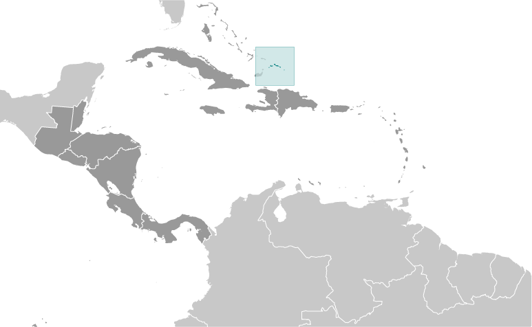
Two island groups in the North Atlantic Ocean, southeast of The Bahamas, north of Haiti Geographic coordinates
21 45 N, 71 35 W
Map references
Central America and the Caribbean
Area World Ranking: 186
Total 948 sq km
Land 948 sq km Water 0 sq km Area - comparative
2.5 times the size of Washington, DC Land boundaries
0 km
Coastline
389 km
Maritime claims
Territorial sea 12 nm
Exclusive fishing zone 200 nm Climate
Tropical; marine; moderated by trade winds; sunny and relatively dry Terrain
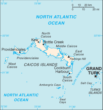
Low, flat limestone; extensive marshes and mangrove swamps Elevation extremes
Lowest point Caribbean Sea 0 m
Highest point Flamingo Hill 48 m Natural resources
Spiny lobster, conch
Land use
Arable land 2.33%
Permanent crops 0% Other 97.67% (2005) Irrigated land
NA
Natural hazards
Frequent hurricanes
Environment - current issues
Limited natural freshwater resources, private cisterns collect rainwater Geography - note
About 40 islands (eight inhabited)
Comments
Add a new comment: |
Advertisement
Members area
Turks And Caicos Islands [ United Kingdom ] (Overseas Territory):
GPS points from Turks And Caicos Islands [ United Kingdom ] (Overseas Territory)
|
||||||||
 The islands were part of the UK's Jamaican colony until 1962, when they assumed the status of a separate crown colony upon Jamaica's independence. The governor of The Bahamas oversaw affairs from 1965 to 1973. With Bahamian independence, the islands received a separate governor in 1973. Although independence was agreed upon for 1982, the policy was reversed and the islands remain a British overseas territory.